It is hard to imagine now, but just 12 months ago my walking was limited to the paved sidewalks and I’d never used such terminology as “out-and-back” and “elevation gain”. I did not own a pair of trusty hiking boots and had never measured my speed in terms of “minutes per mile”. Things are very different today because I’ve logged about 800 miles and 350 hours of hiking since July of 2013. You see, I’m about to embark on a once-in-a-lifetime trekking expedition to the tallest mountain in Africa (Mt. Kilimanjaro), accompanied by my two sons and ten friends.
My story, however, is not about a distant African mountain. I’d like to share with you my discovery of the most beautiful land located practically in our own backyard.
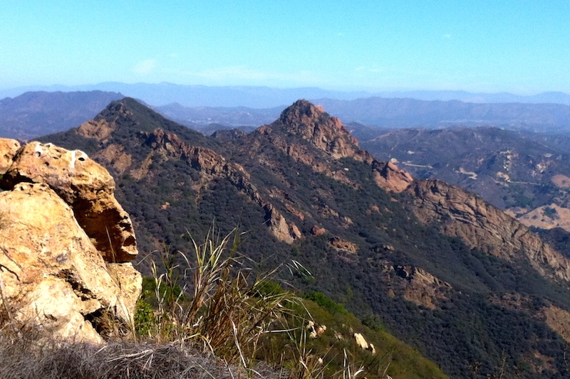
Do yourself a favor as you drive toward the Pacific via Topanga Canyon, Malibu Canyon or Kanan Road – glance over your steering wheel at the range of hills and peaks towering above the winding road. A completely different world exists just a few hundred feet above the snaking beach-bound traffic. This world offers shady forests, peaceful valleys, abandoned movie sets, cool streams, wild flowers, waterfalls, grazing deer, empty trails and stunning views of the mountains, blue sky and sparkling ocean.
You can simply walk into this universe, as long as you know where to find a few entry points, a.k.a. the trail-heads, and you won’t even have to pay a dime to enjoy this amazing place. Trust me – there are hundreds of trail miles to explore, suitable for virtually all levels of ability and physical conditioning. I will share with you just a few routes, which you can enjoy within a 15-minute drive from the Calabasas City Hall, but many more are located just around the corner.
A Gentle Intro
As soon as I strapped on my first pair of hiking boots, I wanted to break them in on a fairly forgiving trail. I drove my car to the De Anza Park, the usual epicenter of our annual Calabasas Pumpkin Festival, walked behind the Community Center building and took the Las Virgenes Trail, which runs parallel to the Las Virgenes Rd. It took me 1.5 hours and about 5 miles to complete the “out and back” walk to Mulholland Hwy and return to the De Anza Park. I remember listening to a very funny audiobook on my iPhone and seeing a grazing deer family as I walked a few yards away from them. I was ecstatic from my first hike!
Next thing I did was to invite a few friends for a pleasant hike from the south-west corner of Las Virgenes Rd and Mulholland Hwy into the Malibu Creek State Park. We had walked for about 1.5 miles along the Grasslands Trail to reach the quiet Century Lake and another 1.5 miles toward the former M.A.S.H. TV series set. It was a wonderfully enjoyable Saturday morning.
Cranking up the volume
Then it was the time to increase the intensity of my hikes, which is directly proportional to the increased vertical gain (how steep is the ascent) and the distance covered.
If you are ready for some fun, then park your car on a dirt lot located on Stunt Road (1 mile up from Mulholland Hwy), cross the street and enter a wide dirt road, called Calabasas Peak Fire Rd. Walk up a fairly steep mile to get to a bench where two trails merge. You will have an option to turn right and descend into a picturesque Red Rock Canyon or to continue up the same fire road for another mile to reach Calabasas Peak, which rises 2,165 feet above the sea level. Should you decide to go further, you will get to the Old Topanga Canyon Rd. having walked about 4 miles from the parking lot. One time, my friends and I decided to keep on walking until we ended up on the corner of Sunset Blvd and Pacific Coast Hwy, some 15 miles later.
Another great heart-pumping exercise is to park your car on the south-east corner of Piuma Rd and Las Virgenes Rd, walk south for about 300 yards, carefully cross the Las Virgenes Rd and enter the famous Backbone Trail. You will ascend steep 1,500 vertical feet during the next 2.5 miles and reach a beautifully situated picnic table, overlooking the Pacific.
The favorites
I have plenty of favorite trails, which tend to be more challenging than the rest. Among them two different approaches to the Saddle Peak (2,805 feet above the sea level): one from the Old Topanga Canyon Rd via the Hondo Trail and other – from the corner of Piuma Rd and Las Virgenes Rd. There is a wonderful Mishe Mokwa loop, which includes visiting the Sandstone Peak, which stands at 3,111 feet – the tallest point in Santa Mountains. My absolute favorite is the 13 mile loop in Malibu called Zuma Ridge Trail, which offers spectacular views, takes you from the sea level up about 2,000 feet, down to about 500 feet and back up to 2,000 feet before returning to the sea level.
Keeping track of it all
My smart phone tells me everything I need to know about my past, current and future hikes. There are plenty of apps that help you to keep track of your progress and plan the future hikes. Personally, I use MapMyHike.com to help my team and I to get ready for the Mt. Kilimanjaro challenge. You can also visit the website, download their app and befriend me. You will get to see the detailed maps of our previous hikes and see how we’re doing in Africa.
One thing is for sure – hiking has become a big part of my life and I highly recommend it to everyone as well.
Hope to see you in the Santa Monica Mountains soon!
Igor Yasno
www.facebook.com/LenkaTraveler
Good luck and have a great tine in Africa.